Showing posts with label Riding Gravel. Show all posts

3/05/2021

Tips for Cycling During the Transition to Spring

The months of March and April in Minnesota can present all kinds of weather for those that are itching to get out on the bike after a long winter.  These fluctuations can present some challenges to getting out and riding but can be overcome.  Over the years of riding during the "shoulder seasons" I have learned a few things that make the ride a little better and safer.  Below I will share with you some of my tips for cycling during this transition into spring.

With singletrack closed during the freeze/thaw cycle transition into spring, there are options to still ride. This time of year I like to take to the road whether it be gravel or paved. Road hazards are more plentiful than summer months so keep your eyes always scanning your line of travel. Those not comfortable with riding on the road may choose to stick to bike paths and paved trails. If so, use caution at crosswalks and intersections so motorists that aren't used to seeing cyclists this time of year see you.

This transition time of year can present numerous hazards in the roadway that need to be avoided. These can include snow, ice, sand, branches, leaves and litter. Scanning the roadway ahead of you will help you identify these hazards so an evasive maneuver can be safely executed. Dark and low light times require a headlight to help illuminate the roadway to see potential hazards in time. Adjust the headlight beam according your rate of speed so as not to overdrive the lit portion ahead of you.  Doing this will give more time to react when a hazard is identified. 

Ice can present a problem when riding in the morning or after dark as temperatures can dip below the freezing point.  What may appear like wet pavement may be a very thin layer of ice that can take a cyclist down.  I will usually end up walking my bike across the icy section if it is on an uphill or downhill and slowly roll across in a straight line unclipped from my pedals on flat sections.

Gravel roads are always popular with cyclists this time of year as they are a way to get in some saddle time while waiting for the singletrack to dry out.  They can be a little sloppy with snow melt and the occasional rain shower so you may want to strap on some fenders to keep from slinging limestone mud all over your backside.  These low traffic roads provide great scenery, elevation change and challenges like tackling the wind out in the open.  If you're looking to get your bike legs back after a long winter, gravel roads are a great place to start.

Weather can be all over the board in March and April so I follow the forecasts for the time I will be riding. Knowing the forecast will help you choose the proper apparel and be prepared for weather changes.  I never get caught off guard by a passing shower or other inclement weather changes because I will bring extra apparel just in case. I've had to break out my barrier jacket on numerous occasions to stay dry.

The months of March and April tend to have frequent windy days and having good wind resistant apparel will make your ride more comfortable. Wind can make 30°F feel more like 18°F (windchill index) so in addition to a windproof shell, additional layering may be required. I have windproof apparel pieces that cover core, legs, hands, feet, head and face to choose from for varying conditions. Cut the wind to cut the cold.

Temperatures during the shoulder season will determine the proper footwear and sock choices.  I always wear wool socks for the cold but they also help regulate temperature so if it warms up during a ride my socks will wick moisture and keep my feet comfortable.  I will wear a cyclocross style insulated boot until it is warm enough to break out the road shoes.  For those chilly morning or evening rides and when road conditions are wet I like to wear a pair of waterproof shoe covers to keep my feet warm and dry.  They can easily be removed and stored in a jacket pocket if temperatures rise where they are not needed.

I'm an advocate of daytime running lights and use them year round to be better seen by motorists. They are especially useful this time of year because motorists are not used to sharing the road with cyclists. Increase your odds of being seen by always using daytime running lights. 


Rain and melting snow snow will leave roads and paved trails wet and puddle laden. Fender use will help keep you dry and your cycling apparel clean on those days they are needed. Clip-on fenders are a good choice for those that don't want them on all the time. I carry an Ass-Savers fender in my frame bag so I have it handy in the unexpected event that I may need to use it. It's a minimalist rear fender that needs no tools to clip under my seat but does the job nicely at keeping my ass dry. 

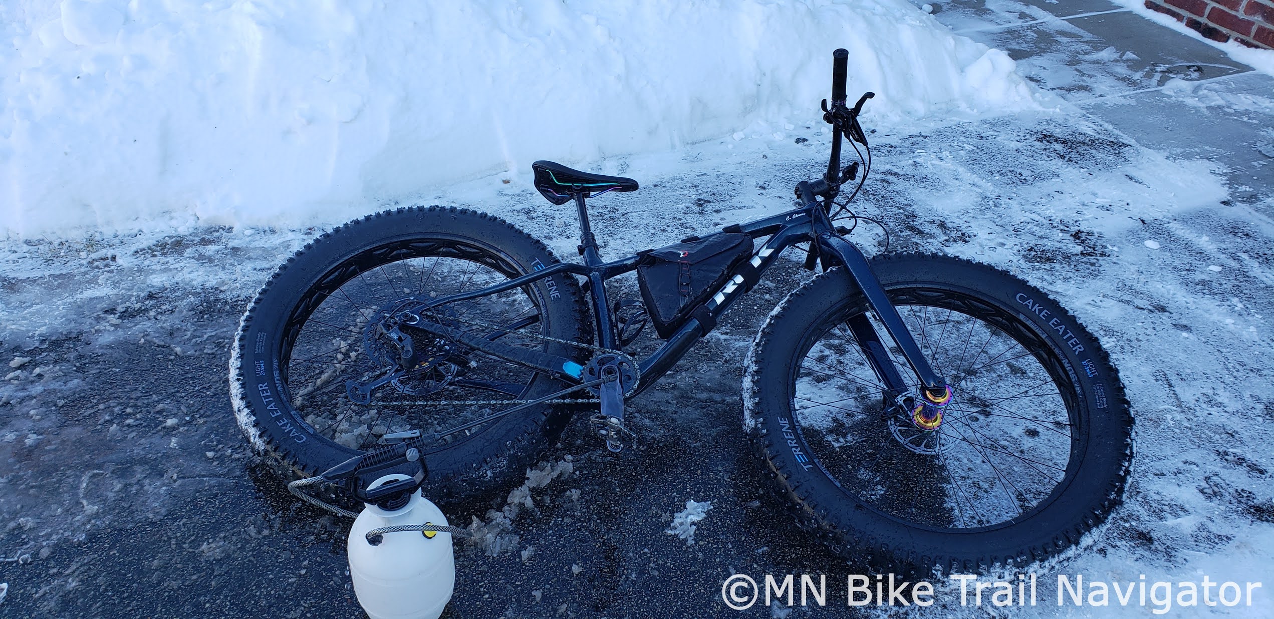
The transition to spring can make your bike a little messy.  Road salt mixed with snow melt can wreak havoc on your bike's drivetrain and components so a good wash down after a ride in these conditions is recommended.  Sand and dirt on roads and trails is more prevalent this time of year so you may find your bike needs a wash more frequently than during the summer months.    

It appears we are going to get an early spring so break that bike out of its long winter slumber and get out there and ride.  Remember, there is no such thing as bad weather, just bad clothing choices.

8/18/2020

Camping at Cuyuna is Easy in a True North Basecamp Cabin Tent


One of my favorite places to ride is Cuyuna and when I do I stay at True North Basecamp. I've stayed at their lakefront cabins before but I wanted to try out camping in one of their cabin tents.  I have most of the camping gear needed from my bikecamping adventures but I didn't feel like spending the weekend in my bivvy tent so this was a much more comfortable option.  It would give me the camping/bike weekend experience without the hassle of setting up and tearing down camp.  All I had to do was unload my gear and bikes and get to riding.


Each cabin tent is a spacious 10'x12" that has enough room for you, a friend and all of your gear.  They come with two padded cots that I will say I slept quite comfortably on.  After the first night's rest I was ready for a full day of hitting the trails.


Cabin tent campsites include a fire ring, picnic table, plenty of trees for setting up hammocks and a nearby vault bathroom. If you don't have a camp stove, meals can be prepared over an open fire.  Firewood can be easily ordered and delivered right to your campsite by texting your cabin/campsite number and quantity of bundles before 2:00 pm for same day delivery.  Charges will be applied to the credit card on your reservation. 


Whether it's paddling the mine pit lakes, hitting the singletrack, riding the Cuyuna Lakes State Trail or crushing some nearby gravel, True North Basecamp puts you right in the middle of all the action Cuyuna Country has to offer.  Being trail connected is why it's my basecamp for a few days of on-the-bike adventures.


The Cuyuna Lakes State Trail is just a short ride from the Basecamp and offers 8 paved miles through woods and past lakes from Crosby to Riverton.  The trail also brings guests to access points for the mountain bike trails and nearby roads for roadies and gravel enthusiasts.


If gravel roads are your thing, Cuyuna has them so bring along that gravel bike.  Try one of the 40, 70 or 100 mile Woodtick gravel loops or plan out your own route with the help of Gravelmap or RideWithGPS.


One of my favorite amenities of True North Basecamp is the on-site access to 30+ miles of Minnesota's best mountain biking at the Cuyuna Country State Recreation Area.  I've been known to stay out on the trails all day with a stop or two back at camp for rest and refreshments.


These world class mountain bike trails offer something for riders of all abilities while providing spectacular views of the surrounding forest and mine pit lakes.


After riding all morning it's time to head back to the basecamp for some lunch and a little break before hitting the trails in the afternoon.  At the basecamp you can hit the trails hard all day or take it in at a leisurely pace.  When you're trail connected it's all just a short ride away.


After a day of riding I can cool off by taking a dip down at the lake or drop a line and try my luck at fishing for northerns and panfish.


When the day is winding down its a short ride or walk to the shower house to get cleaned up and changed before starting up the campfire and cooking dinner.


There is so much to do here that I end up exhausted after a full day of riding and couldn't wait to get back to camp for some much needed relaxation and a cold beverage or two.  When trying to fit your Cuyuna bike adventure into a day trip just won't do, the cabin tents at True North Basecamp make camping easy without roughing it.  Just bring your camping gear and bikes, the campsite is already set up and waiting for you.


True North Basecamp has special weekday rates that can save you cash.  Rent one of the cabin tents Sunday through Thursday for only $49 a night, Friday and Saturday nights are just $65 a night.  Check in time is at 4:00pm and check out is at noon.

To book your stay visit the True North Basecamp website for Cabin and Camping reservations.  For updates and more information visit the True North Basecamp Facebook Page, Twitter Page or send them a message on their contact page.

4/11/2020

Twin Cities Social Distancing Ride Planning


Minnesota's Stay at Home Order has all of us experiencing a little cabin fever and riding a bike is a great way to cure it.  Social distancing is key right now to help flatten the Covid-19 curve but since implementation of the order some Twin Cities trails have become quite crowded.  For those not comfortable with road cycling, bike trails are a great alternative but with fewer people driving I've found taking to the road is more enjoyable now and definitely helps avoid getting too close to others.  Lately I've been using a mix of road and trails, low traffic routes, times of day and the weather to practice social distancing riding with great success.  Another tactic I have been using for some time is to ride from home.  This has helped me discover the bike infrastructure in my neighborhood and beyond.  In this post I will introduce you to some ways to find areas to explore and plan rides to help you avoid the crowds and still put on plenty of miles.

Bikeverywhere
Image Credit: Bikeverywhere

Doug Shidell has been producing the most up-to-date, accurate and readable cycling maps since 1984.  His Twin Cities Bike Map has been a staple for cyclists navigating the Twin Cities for just as long.  It is available in tear and water resistant print form from Bikeverywhere and Twin Cities bike shops for $13.50.  For those that prefer to carry the map on their phone there is a mobile version that works with the free Avenza Maps app for both IOS and Android.  The mobile version of the Twin Cities Bike Map sells for $5.99 and covers 1,000 square miles of bike trails and bike friendly roads.  It works with the GPS in your phone to show you exactly where you are on the map so you can never get lost.  Pick up a print map today or download the mobile version and start exploring the roads and trails in your neighborhood.

Google Maps
Google Maps for mobile has been a long time favorite of mine for getting from point A to point B while cycling.  Using Bicycling Directions in the app, it will help you get to where you want to go by offering several route options showing mileage, elevation gain/loss and estimated travel time.  I have used this many times over the years to find the fastest or best bicycle friendly route to get home when I'm out on one of my ramblings.  

By visiting Google Maps on the web you can plan out a destination ride and send the route directly to your phone to use in the Google Maps app.  A pair of earbuds or a Bluetooth speaker to get turn-by-turn audio directions in real time can be used so you don't have to keep looking at your phone.  Google Maps is a free app that is available for both IOS and Android.

Gravelmap

I've been a gravel advocate for a very long time and these low traffic roads are perfect for practicing social distancing cycling.  With the help of Gravelmap.com you'll see that you don't have to travel far to find gravel roads and routes close to and within the metro area. 


In addition to the changing scenery you'll find that in most cases you have the road all to yourself making gravel a great choice to avoid people out exercising.  Search the map for gravel roads and routes near you today and go on a bike adventure away from everyone.

Tips

Off peak times are perfect for getting out and riding to avoid crowds.  One of my favorite times is early in the morning when everyone is still in bed.  Pedestrian and cycle traffic is very light or non-existent which makes it very easy to practice social distancing.


My other favorite time is just after dark.  By now most others have already got in their walk, ride or errands done and are back home for the night leaving the trails and roads empty.  I can ride areas that are normally busy during daylight hours without having to come near or pass others.


Being a year round cyclist I've ridden in every type of weather and just because conditions aren't ideal doesn't mean it won't be an enjoyable ride.  Staying warm and dry during the spring months is pretty easy with the proper ride apparel for the conditions.  Get out there and ride during the rain, most everyone else will be inside.  Windy days are fun when the gusts are at your back and they add some resistance training to make you a stronger cyclist when they're not.  It's these times when the weather isn't as favorable that there are few people out recreating on the paths and trails.


Housing neighborhoods are another good place to ride to practice social distancing.  Depending on the proximity to main roads and trunk-ways, they can be low traffic making them a good area to do some road riding for those not comfortable with riding on higher traffic roadways.


When I want to get in a road ride but avoid the hustle and bustle of the city I will venture out to the lower traffic country roads near my home.  I've been riding these roads for years and have my favorite routes and roads.  If you are unfamiliar with country roads in your area, plan out a route using Google Maps in the satellite mode.  By zooming in you will be able to tell if the roads you want to ride have a wide shoulder or no shoulder at all.


If I'm riding during hours of the day that tend to see more trail users I will avoid the high traffic areas and opt for those that don't get used as much.  If you are familiar with the trail systems near your home, chances are you already know which ones to steer clear of during peak times. 


Make yourself visible to drivers, other cyclists and pedestrians.  Drivers may not be used to seeing cyclists as much this time of year and with more people out biking during the Stay At Home Order we are currently under in Minnesota there will be a lot more of them to watch out for.  Use daytime running lights front and rear and position yourself to be seen by motorists and others.


There are plenty of opportunities to ride bikes and avoid higher pedestrian and cyclist trafficked areas to practice social distancing.  By using some of the resources and tips mentioned above you should be able to put on some serious solo mileage that will lift your spirits and put a smile on your face.  Now get out there and ride your bike.

Central Lakes Trail
The Central Lakes Trail is a 55-mile trail 
that runs through the heart of 
west-central Minnesota 
from Osakis to Fergus Falls

10/10/2018

Favorite Fall Rides In and Near the Twin Cities-Part 2


Fall is one of my favorite times of the year to ride and right now the leaves in and around the metro are starting to change color.  We have many trails and roads in Minnesota that are perfect for seeing all sights that Fall has to offer by bicycle.  There's something here for every type of cyclist whether you're a mountain biker, trail rider or gravel enthusiast.  Get out there soon as this opportunity comes and goes quickly.   Below are some of my favorites near the Twin Cities that I try to visit this time of year.

Minnesota River Bottoms

The Minnesota River Bottoms network of trails have always been a Fall favorite of mine for riding my fatbike.  The floodplain forest offers great views of the river and wildlife that inhabit this area.  However, with all the rain we have had recently some areas are too soft to ride or are underwater due to flooding.  The Bluffs section between 35W and Mound Springs Park has a high enough elevation where flooding shouldn't be a problem.  Other segments are rideable but there will be some spots that are muddy or under water and you may have to turn back.

The trail conditions in a floodplain are constantly changing so check for updates by visiting the MORC Trail Conditions page or see and hear about other's ride experiences on the MN River Bottoms Ride Report Facebook group.

Cannon Valley Trail/Hay Creek/
Goodhue-Pioneer State Trail

The Cannon Valley Trail is a little over 19 miles long and has trail access in Cannon Falls, Welch and Red Wing.  The trail was built on a former railway grade and offers beautiful views of the Cannon River, woods and prairies along the way.

The ride doesn't have to end in Red Wing.  Hop onto the city trail that follows along Hay Creek and it will lead you to the Goodhue-Pioneer State Trail which also follows Hay Creek with awesome views of  the changing colors as you roll through the Richard J. Dorer Memorial Hardwood State Forest.  Follow the trail until it ends in the little town of Hay Creek which is the turn-around point.  Make a day of it and start at the Cannon Falls Trailhead and ride to the town of Hay Creek for a 52 mile round-trip ride.

Fort Snelling State Park

Fort Snelling State Park has trails to ride through the woods on both sides of the Minnesota River.  Near the historic fort on the north side of the Minnesota River there is plenty of parking and once you head down the hill on the trail near the fort you will come across both paved and unpaved trails on Picnic Island and around Snelling lake.  There is also the paved Minnehaha Trail that follows the Mississippi River north through the woods to Minnehaha Park.


Some of you may be very familiar with the Mendota Trail that follows along the Minnesota River on the south side from Mendota all the way to the Cedar Ave. bridge.  This section of natural treadway trail offers many views of the river as it meanders along through the woods past creeks, lakes and marshes.  With all of the rain we have had recently, some sections of the trail are very wet and/or underwater so keep that in mind.  Updates and photos for this section of trail can be found at the MN River Bottoms Ride Report Facebook group page.

Lilydale/Harriet Island Regional Park

The paved trails that run through Lilydale Regional Park and Harriet Island Regional Park are a joy to ride this time of year.  These trails pass through the floodplain forest along the south side of the Mississippi River from 35E in Lilydale all the way to Harriet Island in St. Paul.  The views of the changing colors along the way are spectacular and it's hard to believe that it's so close to downtown.  These trails also connect in Lilydale to the Big Rivers Regional Trail making for a longer ride along the river and multiple other trail options.  For a better view of the trails in this area, visit Google Maps to plan out your Fall color ride.

Umore Park/Vermillion Highlands

A place I continue to ride year after year in the Fall is close to home for me.  The Vermillion Highlands and UMore Park in Rosemount have paved and gravel roads that take you through part of what used to be the Gopher Works Ordinance plant during World War II and a wildlife management area.  Some of these roads I used to ride have been closed to the public by the University of Minnesota but there are still a lot of areas to see the Fall colors and experience nature.


Explore old paved roads with light car traffic throughout UMore Park on the north side of 160th St. E. and then venture into the Vermillion Highlands on the south side.  Some roads to ride include Station Trail, Annette Ave., 190th St. and Blaine Ave.  Just off of Station Trail is the entrance to Whitetail Woods Regional Park that has a picnic area and restrooms. 


Don't delay as the Fall colors don't stick around for long.  Visit one of the areas mentioned in this post if you haven't before and experience Minnesota Fall on a bicycle.

10/06/2018

Favorite Fall Rides In and Near the Twin Cities-Part 1


Fall is one of my favorite times of the year to ride and right now the leaves in and around the metro are starting to change color.  We have many trails and roads in Minnesota that are perfect for seeing all sights that Fall has to offer by bicycle.  There's something here for every type of cyclist whether you're a mountain biker, trail rider or gravel enthusiast.  Get out there soon as this opportunity comes and goes quickly.   Below are some of my favorites near the Twin Cities that I try to visit this time of year.

Lebanon Hills

One very popular spot for mountain bikers in the Twin Cities is Lebanon Hills Mountain Bike Trails.  With the majority of the trails in a hardwood forest, this is a prime spot to ride right among the changing colors.  Lebanon Hills has over 12 miles of beginner to expert level trails making it a great ride for mountain bikers of all abilities.  Fall's wet weather does present some challenges though so make sure the trails are open before heading out to there for a ride. Visit the Lebanon Hills Mountain Bike Trail Facebook page or the MORC Trail Conditions page for the latest updates on trail conditions and closings.

Minnesota River Bluffs LRT Regional Trail

The Minnesota River Bluffs LRT Regional Trail is a 12 mile long aggregate trail that runs from Hopkins to Chaska.  It passes through several parks and offers great views of the changing colors around the Minnesota River Valley.  A portion of the trail is closed between Pioneer Trail in Eden Prairie and Highway 101 in Chanhassen due to trail washout from mudslides in 2014 so plan your ride here accordingly and follow the posted detour.

Big Rivers Regional Trail

The Big Rivers Regional Trail in Dakota County is only 4 1/2 miles long but offers great views of the river valley at the confluence of the Minnesota and Mississippi Rivers.  Trail access is available at the East Trailhead on Lilydale Rd. in St. Paul and along Hwy. 13 at I-494, Pilot Knob Rd., Hwy. 55 and I-35E.  The Big Rivers Regional Trail also links to many other area bikeways along both sides of the Mississippi and Minnesota Rivers.  Visit Google Maps to plan out your ride in this beautiful river valley area and make a day of it.

Mississippi River Regional Trail-Dakota County

The south/east segment of the Mississippi River Regional Trail in Dakota County is one of my favorite new trails to ride for great views of the Mississippi River Valley and the hardwood forest that surrounds it.  Access to this part of the trail is available at the Lower Spring Lake Park Reserve Trailhead/West Trailhead, the Schaar's Bluff Trailhead and the Lock and Dame No. 2 Trailhead.  This segment of trail also continues on to the city of Hastings.

For a longer ride, I like to start in Hastings at Levee Park and follow the trail past Lock and Dam No. 2 all the way to the Lower Spring Lake Park Reserve Trailhead/West Trailhead and back for a 21 mile round-trip ride.  A map of this segment of trail can be found here.

Welch Gravel

The Cannon River Valley in and around Welch is a favorite of mine for riding gravel this time of year.  With deep ravines, big climbs, fast downhills and magnificent scenery along the way, this area showcases the Fall colors at their best.  I have returned to this area many times since I first got into gravel back in 2013 and some of these roads are part of the Miesville 56 course which is a gravel rider's favorite.

I have two routes that I like to ride in this area, one on the north side of the Cannon River and one on the south side.  Both of these rides start at the Welch Station on the Cannon Valley Trail.  The Welch-North Loop is a 16 mile ride that is just under 1,000 feet of climbing and the Welch-South Loop is also 16 miles with just over 750 feet of climbing.  Do both loops together for a longer ride, more climbing and plenty of great views that the Cannon River Valley has to offer.  Try mixing it up and doing these routes in reverse for a completely different ride.


Don't delay as the Fall colors don't stick around for long.  Visit one of the areas mentioned in this post if you haven't before and experience Minnesota Fall on a bicycle.  I will add five more of my favorite Fall rides soon in a second segment of this post.
Related Posts Plugin for WordPress, Blogger...