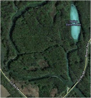
I recently took a bike trip back to one of my favorite areas to fish and hunt when I was a kid. This area known as the
Vermillion River Bottoms located in Ravennah Township near the abandoned town of Etter. It is part of the Mississippi National River and Recreation Area and is very reminiscent of a southern bayou with its vast floodplain forests. I've always wanted to get back here and do some mountain biking and venture through the woods like I used to do years ago. So I took some of the country gravel roads from Hastings down to the Vermillion River South Public Water Access just off the Ravennah Trail and started exploring. Refer to the map for access location.

I headed north near the boat launch on an ATV trail that starts here and proceeds into the woods along the river bank. The trail quickly disappears amongst all of the fallen leaves on the ground. From here it is up to you to blaze your own trail, but as long as the ground is not frozen beware of deep mud along some of the small creeks leading into the river.


I continued north along the river crossing a couple of the small creeks, hopping fallen trees and meandering through the forest until I came upon soft muddy ground. I was riding my 29'er with a 2.25" front and a 2.00" rear tire and figured it would be a good time to turn around and give the east side of the river a try. If I was riding a fat bike with wide tires that provide a little more floatation through the mud I would have continued on. I think I will give this section a try again when the ground freezes making it a little more passable for a standard mountain bike.
I backtracked back to the boat launch and went up to the road to cross the bridge to the east side of the river. Just past the bridge on the north side of the road is a dirt access road that leads down to the riverbank.
I followed this rutted and sometimes muddy path north and east along the narrow river channel off of the main part of the river. The trail soon became wider from 4-wheeler and ATV use.
Eventually I came to Spring Banks Lake where I passed a beaver dam at the south end of the lake.
If you are feeling adventurous or you have a fat bike, you can cross the narrow shallow channel just south of the beaver dam on Spring Banks Lake and venture into more bayou like floodplain woods. A frozen river channel as winter approaches will make this crossing much easier without getting wet in the process.
I pressed on northward along the border of the Mississippi National River and Recreation Area on the east side of the lake through an area ripe with fallen logs to cross and trees to dodge. If you are moving through this area with any speed it will test your sightline decision making skills.
Once through this area I came upon a trail in the woods that started out wide and narrowed the further I went along until it was heavy with trees. I meandered around the area for a little while looking for the best possible travel paths through the thick trees dodging branches, thickets and logs.
Eventually I worked my way back to the bridge and passed under it to check out the area on the other side. There was a small hill to climb and once over it I entered a sparsely wooded area that contained fine sand covered with leaves. Most of the sand was well packed and travel through here was quite easy with very few downed trees.
After about 300 yards I came to the eastern border of the Mississippi National River and Recreation Area and the woods turned to a grassy field area along the river bank.
I turned back at the border and rode around for a bit in woods I had just come from and saw border markings and No Trespassing signs along an old fence. I made sure to stay to the west of this line to stay in public lands.
 |
| View of the island from the bridge looking northwest |
Heading back to the bridge, I took this photo to show the large island area that will remain unexplored until the eastern channel freezes over allowing dry passage onto it.
 |
| My Trails screenshot of the area |
If you don't know the area it can be easy to get turned around and not know where you are at. I recommend exploring with a GPS or GPS enabled smartphone using apps such as
My Trails,
Endomondo Sport Tracker Pro,
MapMyRide or any iPhone app that allows you to track your ride. Use these to find your way back in the event you get lost or aid you to head the right direction. I used My Trails to map out and track where I explored and it was very helpful in getting my orientation a couple of times. Saved tracks will let you reference where you have been so the next time you come here you can go right to unexplored areas of this vast forest floodplain.
I had a great time riding in the Vermillion River Bottoms and plan on returning again soon. I like the fact that there is not really any set trails and it allows a rider to make their own while exploring this beautiful area. Fat bike riders will have a field day here with all of the route possibilities available.


 I recently took a bike trip back to one of my favorite areas to fish and hunt when I was a kid. This area known as the Vermillion River Bottoms located in Ravennah Township near the abandoned town of Etter. It is part of the Mississippi National River and Recreation Area and is very reminiscent of a southern bayou with its vast floodplain forests. I've always wanted to get back here and do some mountain biking and venture through the woods like I used to do years ago. So I took some of the country gravel roads from Hastings down to the Vermillion River South Public Water Access just off the Ravennah Trail and started exploring. Refer to the map for access location.
 I headed north near the boat launch on an ATV trail that starts here and proceeds into the woods along the river bank. The trail quickly disappears amongst all of the fallen leaves on the ground. From here it is up to you to blaze your own trail, but as long as the ground is not frozen beware of deep mud along some of the small creeks leading into the river.
 I continued north along the river crossing a couple of the small creeks, hopping fallen trees and meandering through the forest until I came upon soft muddy ground. I was riding my 29'er with a 2.25" front and a 2.00" rear tire and figured it would be a good time to turn around and give the east side of the river a try. If I was riding a fat bike with wide tires that provide a little more floatation through the mud I would have continued on. I think I will give this section a try again when the ground freezes making it a little more passable for a standard mountain bike.