Showing posts with label St. Paul Trails. Show all posts

7/26/2020

Five Twin Cities Trails to Beat the Heat


The dog days of summer can get pretty hot and steamy in Minnesota but that doesn't have to mean an uncomfortable ride.  The Twin Cities area has quite a few trail systems that run through the cool shade of the woods that I frequent during hot days.  Below I will share some of my favorites to ride to beat the heat.

Brown's Creek State Trail

The Brown's Creek State Trail is a 5.9 mile long rail trail that runs from Grant to Stillwater through a canopy of trees that keeps riders cool on a hot day.  Trail users will parallel Brown's Creek for about two miles and the St. Croix River for another mile as they make their way along this scenic trail.  For those looking to get in some extra mileage, the trail connects to the Gateway State Trail, local trail systems and the newly opened 4.7 mile St. Croix River Crossing Loop Trail.  Parking for the Brown's Creek State Trail can be found in Downtown Stillwater, the Brown's Creek Nature Preserve and under the Gateway State Trail bridge in Grant.

Dakota Rail Regional Trail

The Dakota Rail Trail has been a long time favorite of mine for its scenic ride through woods and along lakes and wetlands.  This 14.84 mile paved trail connects Wayzata with Lake Waconia and extends another 12.5 miles (Carver County segment) to the county line just west of New Germany.  A frequent stop along the trail for me is Cathy Mackenthun's Meats & Deli in St. Bonifacius for a quick lunch and to stock up on some of their award winning smoked meats, bratwurst and jerkey.  Parking is available at numerous locations along the trail making it easy to pick the round trip distance you would like to ride.

Mendota Trail

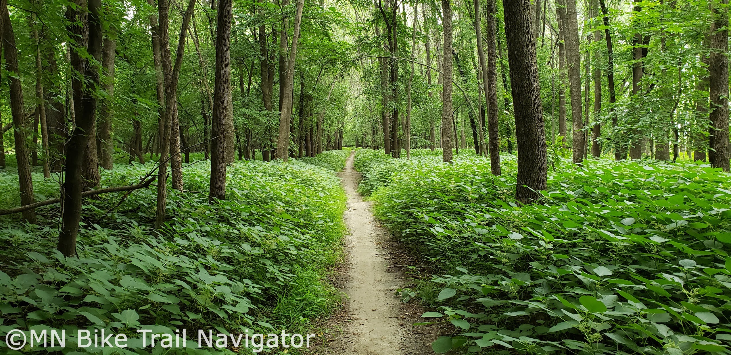
When I want to get in some dirt riding through the cool of the woods, the Minnesota River Bottoms' Mendota Trail in Fort Snelling State Park is my "go-to" spot.  This trail travels 6 miles along the Minnesota River's south bank from underneath the 77 Bridge in Eagan to the Sibley House Historic Site in Mendota. With connectors like the 494 Bridge, Mendota Bridge, Big Rivers Regional Trail and Minnesota River Greenway, different mileage route options for a multi-surface ride are quite numerous.  Parking can be found in Mendota and underneath the 77 Bridge in Eagan.

Gateway State Trail

The 18 mile Gateway State Trail takes cyclists northeast from St. Paul to Pine Point Park just outside of Stillwater.  With plenty of connections including the Bruce Vento Regional Trail and Brown's Creek State Trail and numerous parking locations along the trail, varying routes can be planned for the mileage you would like to do.  The scenery changes from urban to rural as riders pass lakes, woods and wetlands on the way towards Stillwater.  With plenty of trees along the trail this is one ride that will help you stay cool on those hot summer days.

Lake Minnetonka LRT Regional Trail

The Lake Minnetonka LRT Regional Trail has been a longtime favorite of mine for its scenery as well as shade on hot days.  This 15.92 mile aggregate trail stretches between Hopkins and Carver Park Reserve in Victoria as it passes by Lake Minnetonka and through numerous communities along the way.  Make sure to stop in Excelsior for a pint at Excelsior Brewing or Sebastian Joe's Ice Cream at Tommy's Tonka Trolley on the waterfront.  For those that like a little longer ride, take a trip around Lake Minnetonka by traveling through Carver Park Reserve to St. Bonifacius and jumping onto the Dakota Rail Trail on your way to Wayzata and back to Hopkins.  Parking can be found at numerous locations along the trail but I tend to start near the Depot Coffee House in Hopkins at the junction of the Cedar Lake Trail and the Minnesota River Bluffs LRT Regional Trail.

1/25/2017

MPLS Winter Biking Is New Interactive Site for Twin Cities Bike Commuters


MPLS Winter Biking is an online resource launched a couple of days ago by Foundry, a software design & development agency based in Minneapolis, that allows bike commuters in the Twin Cities to report and view trail/road conditions.  It works for both desktop and mobile devices.  Users of site can rate and add comments to their reports by clicking the map for the road or trail they would like to inform other cyclists about.


MPLS Winter Biking is interactive using Google Maps with Bicycling routes highlighted and user submitted reports are color coded based on the 5 star rating system.  Reports indicate whether or not they contain an optional comment on the conditions.  Cyclists can zoom in to report for a specific road or trail and each report shows the date and time of  the submission.  To keep the map information current, user submitted reports are only 3 days old or less.  Over the last day and a half, a lot of new reports have been submitted detailing how the commuter conditions have changed with the new snow we have received.

Whether you're an avid or occasional bike commuter, put this resource to use by submitting your reports so that other cyclists can be in the know and plan their routes accordingly.  Your fellow cyclists will thank you.

8/19/2016

Getting To The Great Minnesota Get Together By Bike


Avoid traffic congestion and the high cost of parking at the Great Minnesota Get Together by riding your bike.  The Minnesota State Fair has free secure and monitored bike parking at three locations.  The bike corrals are located at the Como-Snelling Gate (#6),  Hoyt-Snelling Gate (#2) and Randall-Buford Gate (#17).  They remain open daily from 6 a.m. to midnight.  Click here to download a printable color map of the Minnesota State Fair.

Image Credit: Minnesota State Fair

For State Fair goers that may have a longer commute, they can park and lock their bikes at one of several Park & Ride lots and take the bus for free to and from the fair.  These Park & Ride locations include:
  •  Roseville Area High School East of Hamline on Co. Rd. B2.  Not available Tuesday, August 30th or Thursday, September 1st.
  •  MN Dept. of Education East of Target, north of Co. Rd. B. (Pascal St. & Commerce St.). 
  •  U of M Minneapolis Campus (Not available Thursday, September 1st).  Various surface lots near TCF Bank Stadium along 6th Street SE and 8th Street SE open at 8 a.m. daily. 4th Street Ramp opens 4 p.m. weekdays and 8 a.m. weekends & Labor Day.
  •  Bandana Square North side of Energy Park Drive, east of Snelling Avenue (Weekends and Labor Day only).
Park Free, Ride Free bus rides are available from 8 a.m. to midnight and buses leave approximately every 20 minutes.  For a map of the Park Free, Ride Free locations, click here.


For Nice Ride MN subscribers, there is a Nice Ride Station located near the MN State Fair.  The U of M St. Paul Student Center Station is on Buford Ave. and is a short walk to Gate 16 by the Transit Hub.  Use the new Nice Ride Bike Share app for station locations, bike/dock availability and to rent/unlock bikes.

Image Credit:  Ochen K. from Bike Racks - Minnesota State Fair on Vimeo

There are several resources available to plan out your bike route to the fair.   BikeEverywhere has a Bike to the State Fair map that shows on-road, bike path next to road and bicycle corridor trail routes leading to the fair.  Please note that Lot 3 on this map has been moved from Commonwealth Ave. and West Dan Patch Ave. to the Randall-Buford Gate (#17).  Bike Walk Move has a downloadable Bicycling & Walking Como Avenue map that shows off-street bike paths and recommended on-street bike routes leading to the State Fairgrounds.  Cyclopath is a great tool for route planning.  Simply enter the beginning and ending addresses and it will find a bike route that matches the way you ride.


Google Maps using Bicycling Directions is also another great way to plan your ride to the Great Minnesota Get Together.  Enter the starting and ending points on your PC or by using the Google Maps app on your smartphone and you will be given several route choices. When using your computer you can even choose to send the route to your Google connected smartphone.  The Google Maps app even has an option to enable voice guided turn-by-turn directions so you can keep your eyes on the road.

Don't get stuck in traffic or pay the $13 State Fair parking fee.  By biking to the fair or using the Park Free, Ride Free bus service you can save yourself some money, enjoy the ride and arrive close to an entrance gate.

PLEASE NOTE that neither the fair bike corrals nor the Park & Ride lots provide for secure storage of bike helmets.

    4/01/2014

    Get the Latest Mountain Bike Trail Conditions and Check for Closures Before You Ride

    With the changing of the seasons comes mountain bike trail closures, especially during the freeze/thaw cycle.  These closures are put into effect to prevent trail damage and erosion.  Mountain bikers are anxious to get out and ride during the Spring but need to respect these closures and stay off wet trails.  This will save MORC and other IMBA Chapter volunteers hours of trail repair time.  Bookmark this post and check back often to see current MORC trail conditions, get trail information and maps.  For the latest Cyclecast, visit 2WheelWeather's MORC Weather Blog.

    Battle Creek Regional Park
    Maplewood
    Image Credit:  MORC

    Carver Lake Park  
    Woodbury 
    Map     Trail Info     Facebook  
    Image Credit:  Mountain Bike Geezer

    Eagan Bike Park
     Eagan
    Image Credit:  Eagan Bike Park Facebook page

    Elm Creek Park Reserve
    Maple Grove
    Map     Trail Info     Facebook
    Image Credit:  Griff Wigley

    Hillside City Park* 
     Elk River
    Image Credit:  Griff Wigley


    Lake Rebecca Park Reserve
    Rockford
    Map      Trail Info
    Image Credit:  MORC

    Lebanon Hills Regional Park-West
    Eagan
    Map     Trail Info     Facebook     Twitter


    Mendota Trail (MN River Bottoms)
    Eagan
    Map     Trail Info


    Minnesota River Bottoms
    Bloomington
    MORC Trail Conditions


    Murphy-Hanrehan Park Reserve
    Savage
    Image Credit:  MORC

    Salem Hills/Harmon Park Reserve
    Inver Grove Heights  


    Terrace Oaks Park West
    Burnsville


    Theodore Wirth Park
    Minneapolis
    Map     Trail Info     Facebook     Twitter
    Image Credit:  Mountain Bike Geezer

    *fee required

    MORC Trail Condtions from around the state:


    From MORC:

    Why Are Trails Closed?

    Sustainable trails are built so that water will run across the trail, not down it. When water runs down the trail it focuses the water and increases erosion. Riding wet trails creates ruts that will focus the water and increase erosion.

    Riding wet trails also increases cupping of the trail surface and causes puddles to get deeper and wider, both of which slow the recovery of the trail.

    Trails are closed (and often fenced off) during the freeze/thaw cycle in the fall and spring. During these times, trails are especially susceptible to significant damage.

    Trails may also be closed after significant weather events, or if there are unsafe trail conditions.

    The trails around the Twin Cities metro area are particularly sensitive due to the very large numbers of users these trails get every year.

    When trails turn into maintenance headaches, land managers start to consider closing trails for good... PLEASE do your part to ensure that we have access to great trails by riding responsibly. Together we can keep these mountain biking opportunities available for generations to come!
    Wet Trail Conditions
    Beyond major closures, knowing when not to ride after a rainfall can be less obvious. Trails will not be posted as closed or fenced off after normal rainfalls/storms, so it is up to you to make an educated decision. Here are some general rules regarding wet conditions:

    - Trails should not be used during wet weather, or when the trail is soft or muddy.
    - Trails are open if the trail is firm and the surface will not be disturbed by foot or bike travel.
    - PLEASE be patient if the trail isn't ready... allow the trail to dry before riding.
    - Trails are typically too wet to ride for 18-24 hours after a significant rainfall.
    - Riding wet trails damages the trail by creating ruts that increase erosion.

    Please check the Trail Conditions Pages above for the most up-to-date information. And if you ride a trail, please take a minute and update the conditions if they haven't been updated in a while... this is a great way to both help out your fellow riders and help preserve the trails we love! 

    3/18/2014

    The Twin Cities 100 Showcases Our Extensive Urban Trail System


    The Twin Cities 100 is an urban bike ride in its second year.  Ride founder and director, Ryan Diedrich told me, "We ride a loop based 100-mile course through the existing urban bike trails, lane and boulevards of Minneapolis-St. Paul Metro area."  The mission statement for the ride is simple, "The Twin Cities area has one of the most extensive and active urban trail systems in the U.S. We want you to get out there and enjoy it!"
     
    Image Credit:  The Twin Cities 100

    This free and unsupported ride is open to all ages and abilities and will be held on Saturday, September 6th starting at a base camp set up at the picnic area near the Lake Harriet Bandshell in Minneapolis.

    The Twin Cities 100 recently released the following statement:

     Hello Everyone!

    We are very proud to announce that registration is now open for the 2014 Twin Cities 100 Urban Bike Ride!


    Following last years incredibly successful 2013 Twin Cities 100 Founder’s Ride we have made some serious upgrades with a brand new website, including streamlined registration, new ways of giving back to support the cause (Donations!) and a shiny new merchandise store (arriving shortly)!


    For those of you new to the Twin Cities 100, simply put:
    “We are a gathering of passionate cyclists who set out each fall to experience and showcase the amazing cycling infrastructure that the Minneapolis - Saint Paul metro area has to offer.“


    Each fall we host a FREE urban bike ride that takes you through 100 miles worth of these two great cities. Last year we held our Founding Ride with a turn-out that was far better than we had ever
    anticipated going into this and we met some great people along the way who showed up, had a fun time out there riding the trails, getting to know new people and experiencing what the cities have to offer. And that is what the Twin Cites 100 hopes to stand for.
     

    The 2014 Twin Cities 100 will be held on Saturday September 6th at 7:30am and will conclude when you cross the finish line 100 miles later. The ride is free, open to all ages and ability levels and is a completely self-supporting course. Course details are to follow, but for now get on over to our new website at www.ridetwincities.org, fill out a FREE registration form and do please consider giving a donation.

    There is no cap on registration, so please spread the word!


    We hope to see you on the trails!


    Sincerely,
    Ryan & The Twin Cities 100 Crew


    We wouldn't be able to make it happen without your support!
    In order to keep these great rides free and to ensure that we are able to provide the best organization and the most enjoyable events we need your support. Any donations large and small are extremely welcome and will be put to good work in providing the best ride for years to come.
     

    You can contribute to our ride at www.ridetwincities.org/sponsorship
    100% of every donation goes directly to programming. We deeply appreciate your support.

     
    Image Credit:  The Twin Cities 100

    For more details on the Twin Cities 100, visit the Ride Information page and then head over to the Registration page for your free registration and waiver.  If you would like to be a supporter by making a donation, becoming a sponsor or a volunteer, please visit the Sponsorship page.

    8/23/2013

    Avoid Traffic Congestion and Parking Fees by Biking to the MN State Fair


    Avoid the traffic congestion hassle and the high cost of parking at the Great Minnesota Get Together by riding your bike to the fair.  The Minnesota State Fair has free secure and monitored bike parking at three locations.  The bike corrals are located at the Como-Snelling Gate (#6),  Hoyt-Snelling Gate (#2) and Commonwealth-West Dan Patch (#15).  They remain open daily from 6 a.m. to midnight.  Click here to download a printable color map of the Minnesota State Fair.

    Image Credit:  Ochen K. from Bike Racks - Minnesota State Fair on Vimeo
    For State Fair goers that may have a longer commute, they can park and lock their bikes at one of several Park & Ride lots and take the bus for free to and from the fair.  These Park & Ride locations include:
    • Roseville Area High School East of Hamline on Co. Rd. B2.
    • MN Dept. of Education East of Target, north of Co. Rd. B. (Pascal St. & Commerce St.).
    • U of M Minneapolis Campus (NOT AVAILABLE THURSDAY, AUG. 29)  Various surface lots near stadium along 5th and 6th Streets SE as well as 25th Avenue SE open at 8 a.m. daily. 4th St. Ramp opens 4 p.m. weekdays and 8 a.m. weekends & Labor Day. 
    • Bandana Square North side of Energy Park Dr., east of Snelling Ave.
    Park Free, Ride Free bus rides are available from 8 a.m. to midnight and buses leave approximately every 20 minutes.  For a map of the Park Free, Ride Free locations, click here.

    For Nice Ride MN subscribers, there are two Nice Ride Stations located near the MN State Fair. The U of M St. Paul Campus Station is located on Commonwealth Ave. near the Commonwealth-West Dan Patch gate and the U of M St. Paul Student Center Station is on Buford Ave. about a half mile walk from the Commonwealth-West Dan Patch gate.  Use the Spotcycle app for station locations and bike/dock availability.

    There are several resources available to plan out your bike route to the fair.   BikeEverywhere has a Bike to the State Fair map that shows on-road, bike path next to road and bicycle corridor trail routes leading to the fair.  Bike Walk Move has a downloadable Bicycling & Walking Como Avenue map that shows off-street bike paths and recommended on-street bike routes leading to the State Fairgrounds.  Cyclopath is a great tool for route planning and is available for the seven county metro area.  Simply enter the beginning and ending addresses and it will find a bike route that matches the way you ride and there is a Cyclopath app can be used with Android smartphones.

    Don't get stuck in traffic or pay the $12 State Fair parking fee.  By biking to the fair or using the Park Free, Ride Free bus service you can save yourself some money, enjoy the ride and arrive close to an entrance gate.

    PLEASE NOTE that neither the fair bike corrals nor the Park & Ride lots provide for secure storage of bike helmets.

    4/19/2013

    Zap Twin Cities: Encouraging and Rewarding Commuting By Bike in Minneapolis & St. Paul


    Zap Twin Cities is looking for St. Paul, Minneapolis and University of Minnesota commuters to get "Zapped".   The program was first implemented in 2012 by the University of Minnesota in January, then by Commuter Connection for Minneapolis in August and by St. Paul Smart Trips for St. Paul in September.  The goal of the program is to promote and increase bike commuting in the Twin Cities Metro area.  It provides incentives and rewards for those that already commute by bike and encourages others to start commuting by this method.  This is a completely free program and trip counts are automatically uploaded.  Participation in Zap Twin Cities will save you money on gas and parking, provide eligibility for great prizes and is a fun way to improve your health.


    Image Credit:  Joe Bielawa
    Image Credit:  Joe Bielawa
    Registering and getting tagged is easy.  A small RFID tag is installed in the spokes of your front wheel and then you just register online.  There are several locations to get tagged.  University of Minnesota students and staff can get tagged at the U of M Bike Center during normal business hours or at a mobile "Zap Zone" tent to pop up around campus this spring.  In Minneapolis you can bring your bike or front wheel to Commuter Connection located at the US Bank Plaza-Skyway 220 S. 6th St. Suite 230.  Commuter Connection will also have a booth at the Minneapolis Farmers Market and at events around Minneapolis throughout the spring and summer to get cyclists tagged and registered.  Minneapolis commuters can also get tagged at the Freewheel Midtown Bike Center on the Midtown Greenway or at Varsity Bike and Transit.  St. Paul commuters can bring their bike or front wheel to St. Paul Smart Trips located in the Alliance Bank Center at 55 E. 5th St. Suite 202.  Call ahead at 651-224-8555, ext. 23 or 24 and they will make sure they are in to tag your bike and get you registered when you stop by.


    Zap stations are strategically located around Minneapolis, the University of Minnesota Campus and in St. Paul.  As a cyclist passes by these Zap stations an audible beep and a flash of light will indicate that the ride has been registered.

    Minneapolis
    Minneapolis has 12 Zap readers (orange) and the University of Minnesota has 19 (yellow).

    St. Paul
    St. Paul has 7 Zap readers (blue) around the downtown area.

    Image Credit:  Joe Bielawa
    Image Credit:  Joe Bielawa
    To get zapped, a cyclist simply has to look where the Zap station antenna is pointing and pass by within 5 to 15 feet of the "Zap Zone", not on the sidewalk side or directly below the unit as indicated in the picture below.  The audible sound and light will indicate a successful Zap.  Riders only need to be zapped once per day to receive a round trip ride credit.


    The online web app keeps track of all of your Zap ride statistics so manually recording them is not necessary.  Log in at the Zap Twin Cities homepage to access how many trips you have logged in a given time period,  mileage totals, CO2 you have saved, gallons of gas saved, calories you have burned and if you are a member of a team you can see how yours compares to others.


    Zap Twin Cities rewards have been supported by local bike shops that donate prizes and the program will expand this year to include gift certificates to restaurants, movie theaters, and tickets to sporting events.  After logging ten rides cyclists automatically receive a prize.  Each month that a participant in the Zap Twin Cities program registers eight rides they are automatically entered into a drawing for valuable prizes.  Prizes are different every month, so get tagged, registered and start getting Zapped.  University of Minnesota students and staff that are UPlan Medical Program-covered participants can bike their way to health care savings by earning points for their Wellness Points Bank when they have 50 trips recorded as part of the Bicycle Commuter Program.


    Employers that would like to implement Zap Twin Cities as part of their own health and wellness program can contact the Commuter Connection and they will help get you started.  

    Stay up to date on the Zap Twin Cities program by liking them on Facebook or following on Twitter (@ZapTwinCities). 

    This program is a cooperative project of Commuter Connection, St. Paul Smart Trips, the University of Minnesota and Dero Bike Rack Company.
    Related Posts Plugin for WordPress, Blogger...