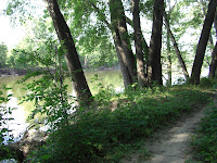
I hadn't been to the Minnesota River Bottoms since the end of May and I decided to make the trip and see how the trail conditions were after the flooding. I also wanted to investigate if there was still a crossing at Nine Mile Creek, if there were any downed trees blocking the trail that needed removal and how overgrown the underbrush had become. Was the network of trails still passable or did you need a machete to get through? There wasn't much current information on the condition of the trails on MORC's Trail Conditions Forum other than it was "Dry", "lushly overgrown with grasses at points" and "plenty of loose sand in the center section", so I wanted to see for myself and to let others know.
 Trail conditions in the refuge change throughout the year so I prepared accordingly. Workout pants for the overgrown underbrush, grasses and stinging nettles, proper footwear, bug spray for the millions of mosquitoes that inhabit the area, sunscreen and water bottles. I also made sure I brought along a spare tube, tire levers and a CO2 inflator in the event of a flat.
 I started out from the Lyndale Avenue Minnesota Valley National Wildlife Refuge parking lot in Bloomington and headed west with my destination being the Bloomington Ferry Unit parking lot.

 It wasn't very long into the ride before I encountered the first downed tree in the trail. It was in the 11 Mile section of the trail, but a detour trail had already been established and getting around it was not a problem. I continued on and it was smooth going all the way to Nine Mile Creek.
 When I got to Nine Mile Creek I was pleasantly surprised to see that MORC had put in place the ferry crossing raft. Earlier in the season, the only way to get from one side to the other was to pick up your bike and walk it across a large fallen tree. With the recent flooding, the log pile at the east end of the tree was washed away making it a little more difficult to get onto it without getting wet. After my ride I spoke with Pat Sorensen from Penn Cycle and he informed me that MORC had placed the raft two weeks earlier.
 The Mile 12 section of the trail has some tall grassy fields and lengthy loose sand areas that require some legwork and balance to get through. Wider tires for floatation will help make easier work of the sandy sections. Fat tire bikers will be able to roll through these areas with ease.
Mile 13 is a little easier going and a faster ride, but still has some areas of tall grasses and weeds.
Mile 14 contains more of the same with the exceptions of a downed tree in the trail (detour already in place) and a longer section of very tall grasses in a field area that makes it hard to see the trail when you are speeding through.
Mile 15 to the Bloomington Ferry Unit is smooth sailing. The trail is pretty clear and wide without the tall, thick underbrush and grasses of earlier mile marker segments. You can get your speed up through this last mile of trail. Take a break at the Bloomington Ferry Unit kiosk or take in a view of the river from the bike/pedestrian bridge and head back to the start.
My overall impression, it's still a fun, fast ride. Just go there prepared with the proper clothing, gear and plenty of mosquito repellent. The trails are completely passable and the only really challenging areas continue to be the loose, sandy sections and the low visibility areas through the tall grassy fields.
*Update note: This report in 7/15/12 from the MORC Trail Conditions Page for the Minnesota River Bottoms. "Trail was in good shape on Thursday, BEFORE it was mowed. Now that it's been cut it's even BETTER! Almost makes me wish there was a "like" button.
There is a downed tree that's very rideable near the old foundation between the swing bridge and the ferry. Watch out coming down because if you ride too far from the root-ball it's a steep drop. Found out that you can endo really good there."


No comments:
Post a Comment