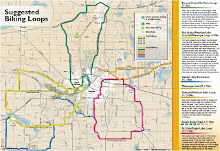
 The greater Mankato area in southern Minnesota has been known for a long time by cyclists as one of the premier biking destinations in the state. Mankato and North Mankato have been recognized by the League of American Bicyclists as a "Bronze" Bicycle Friendly Community through their bike infrastructure, promotion and planning for the future.
The Greater Mankato Convention & Visitors Bureau has made it easy to plan your bike getaway to enjoy all this area has to offer. An array of information is available on the Visit Greater Mankato website. Here you will learn about biking the Greater Mankato Area, its wonderful trail system, where to stay, where to dine, area attractions and access the digital version of the 2013 Mankato Visitor Guide.
 |
| Image: Greater Mankato CVB |
 |
| Image: Greater Mankato CVB |
The Greater Mankato area has something for every type of cyclist, from mountain biking and trail riding to the region's many great road cycling routes.
 |
| Greater Mankato Area Trails |
 |
| Greater Mankato Area Road Biking Loops |
Here you will find some of the best trails in the state that contain scenic views of the Minnesota River, the Blue Earth River, Minneopa State Park, city parks and the woods & fields of the Greater Mankato area.
Trail Highlights
Sakatah Singing Hills State Trail
Red Jacket Trail
South Route Trail
North Minnesota River Trail
The North Minnesota River Trail is a 4.8 mile section of trail that starts at Riverfront Drive on the northern end where it connect to the Sakatah Singing Hills State Trail. It finishes on the southern end close to Sibley Park where it connects to the Red Jacket Trail. Trail users will experience great views as it meanders alongside the Minnesota River for most of its length. Trail Map
Mount Kato
Mount Kato has over 7 miles of beginner to advanced mountain bike trails of which 80% are wooded singletrack. The trails are open in late April through October and trail hours are sunrise to sunset. A trail fee of $8 and helmet use are required. Payment drop off is available so bring correct change or a check. A mountain bike season pass can be purchased in the area office for $110 and is also good at Afton Alps. Trail Map
Seven Mile Creek Park
 |
| Image Credit: Minnesota River Basin Data Center |
Events
- Greater Mankato Bike Week takes place May 13-18 with more details coming soon.
- Race #3 of the Minnesota Mountain Bike Series "Bluff Riders Charge" at Mount Kato is going on June 2nd.
- The North Mankato Kids Triathlon and North Mankato Triathlon take place the last weekend in June.
- The 3rd Annual Mankato River Ramble sponsored by the Greater Mankato Bike and Walk Advocates and the Bicycle Alliance of Minnesota is scheduled for October 6th.
Brochures
Click on the images below to view these handy Greater Mankato brochures.
The 2013 Mankato Visitor Guide is also available for download or request a copy by mail. To stay up to date on everything that is going on in the Greater Mankato area "like" Visit Mankato on Facebook or follow on Twitter @visitg8rmankato.


No comments:
Post a Comment