9/30/2012

Bike Trail Picture of the Day - 9/30/12


Riding through the creek valley

Taken 9/30/12

Location:  Battle Creek Regional Park
Trails and Picnic Area
Near Point Douglas Road S.
St. Paul, MN

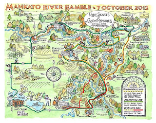
The Mankato River Ramble Returns October 7th


Come ride some of southern Minnesota's  most picturesque trails and quiet country roads in the Second Annual Mankato River Ramble on Sunday, October 7th.  This is a fully supported, go at your own pace ride with three scenic tours to choose from that benefits the Minnesota Bicycle Alliance and the Greater Mankato Bike and Walk Advocates.

Click on map to download a PDF copy
This year choose from a 12, 26 or 42 mile route and see why the American Leauge of Bicyclists named Mankato a Bronze Level Bicycle Friendly Community.


The Minneopa Falls Loop is a 12 mile, traffic-free trail ride to Minneopa State Park and back on the Red Jacket Trail.

The "Pie Run" is a 26 mile ride that starts at the Land of Memories and loops to the Rapidan Dam Store for a slice of their award winning pie which has been featured in Food & Wine Magazine.  The route then ventures on to the Red Jacket Trail for the return.  18 miles of trail are included on this route.


The Lake Crystal Loop is a 42 mile ride that includes quiet country roads and trails. It starts at the Land of Memories and passes through Minneopa State Park on the way to the century old Red Jacket Trail Railroad Trestle overlooking the Le Sueur River Valley.  The ride continues toward Rapidan Dam County Park and passes the the Dam Store at the mile 13 rest stop, don't pass up the pie.  Travel on past Loon and Crystal lakes to the mile 20 rest stop and on to the mile 34 rest stop at Minnemishinona Falls where there will be refreshments and live music.  Continue to finish where you started at the Land of Memories.

The ride will begin at the Land of Memories located just off of  Hwy. 169, one mile past the Riverfront Drive exit in Mankato.  The ride starts at 9:00 am and all riders must be on their route by 10:15 am.  This event will take place rain or shine and helmets are required for all participants.  For answers to questions regarding this event, visit the Mankato River Ramble FAQ Page.

Register online or sign up the day of the event by visiting the Day of Ride registration tent.  Register by October 2nd for $32 or the day of the event for $38.  Youths ages 13-17 are $10 anytime and under 13 are free.  Registration will open the day of the ride at 8:30 am and pre-registered riders can pick up their ID at the appropriate tent.  Click here to download a digital copy of the Mankato River Ramble Ride Guide.

If you would like to volunteer your time to help make this event a success, there are still positions available.  Click here for more information on volunteer opportunities.

9/29/2012

9/24/2012

Progress Being Made on the Pine Bend Bluffs & Central Segments of the Mississippi River Regional Trail


I have been following the reports on the progress of the Mississippi River Regional Trail in Dakota County for over a year now and have become quite familiar with the project.  I wanted to see for myself the stages of completion of the Pine Bend Bluffs segment and the Central segment that connect to the existing MRRT trail.  So I brought along my camera to document the construction of the trail to share with my readers.

Map 1
I started down Cahill Avenue in Inver Grove Heights and followed the existing completed trail.  I found the new section of trail south of Tractor Supply Company that traveled to the Pine Bend Elementary School on Inver Grove Trail.  I have indicated this new trail segment with yellow dots on Map 1.  This is where the trail ended and the Central segment construction began. 

I stopped at the intersection of 100th St. E & Inver Grove Trail to take a few photos of the Central segment trail construction.  The vantage point is marked by the #1 on Map 2 below the photos.

Map 2

The next group of photos were taken from vantage point #2 shown on Map 2 above.


There is an existing trail that starts here on the other side of Courthouse Blvd E. and travels south one half mile to the beginning of the Pine Bend Bluffs section of the trail.  Use Map 3 below as a vantage point reference for the next nine photos.

Map 3

The paving appears to be completed from vantage point 1 connecting to vantage point 3 where minor grading and placing of topsoil on the shoulder of the trail are being done.

Vantage Point #1
Vantage Point #2
Vantage Point #3
Vantage Point #3
Vantage Point #3
Vantage Point #3

Vantage point #3 is where the paved section of trail ends and preparation for paving of the next segment continuing south begins.  These photos were taken from Vantage point #4.


In the southern part of the Pine Bend Bluffs segment on 117th St. E. there is a section that is paved from here to the Rosemount border. The section from 111th St. E to 117th St. E. is prepared and is scheduled for paving between Sept. 21st and 29th.

Map 4

These photos of the paved section to the Rosemount border are taken from Vantage point #1 on map 4 above.


These photos of the trail being prepared for paving were taken from Vantage points #2 & #3 on map 4 above.

Vantage Point #2
Vantage Point #2
Vantage Point #3
Vantage Point #3

It appears as construction of these two segments of the Mississippi River Regional Trail should be completed this fall providing the weather cooperates.  When completed and opened for use, trail users will be able to travel from the Rosemount Border all the way to Kaposia Park in South St. Paul.  The Rosemount segment will be constructed in 2013 and the Spring Lake Park segments will not be completed until 2014.  When all is done, the MRRT will link Hastings with South St. Paul and I'm looking forward to taking the 27 mile trip.

9/23/2012

Bike Trail Picture of the Day - 9/23/12


History in the making

Taken 9/23/12

Location:  Levee Park
Mississippi River Regional Trail
Hastings, MN

Planning Your Next Ride Just Got Easier With Run. Bike. Route. for Android

Run. Bike. Route. for Android is an essential tool that is easy to use for planning your next ride.  No more mapping out your route on the computer, this app allows you to do it using Google's direction service right on your smarthphone.  Map out your ride and know the distance and where elevation changes are beforehand.

Use Run. Bike. Route. for all of your pre-ride planning to set the length of the ride and to locate where those hills are going to be so you are ready for them.  For complicated routes, this app will help you stay on course to prevent taking that wrong turn or getting lost in unfamiliar areas.

Simply open the app, click on the settings icon (wrench in upper right corner) to choose whether or not to show distance markers, satellite image or regular map, default travel mode, distance units, weight units, burn units and default location.  Once these settings are determined you are ready to plan your ride.  You can come back at any time to make changes, but the only one I usually make is to switch between map and satellite mode.


Type in an address to jump to, or zoom in on the map to get to and set your starting point.  Set your starting point by double tapping on the map where you would like to start from.  Continue to double tap at intervals along your desired route or select to "Add a point by address" and automatically plot the route.  If you would like to return to the starting point using the same route, tap "Complete there and back".  Make a mistake?  No problem, simply remove each last plot point by tapping the return arrow to the right of the mileage at the top of the screen.  To save your route, tap on the "Save as..." option and name the route.  Clear the route by tapping "Clear Route".

Below is a round trip route I planned starting at the Cannon Valley Trailhead in Cannon Falls that travels along the Cannon Valley Trail to the end of the Goodhue Pioneer State Trail near Hay Creek. I used the "Complete there and back" option to plot the return route.  These are map and satellite views of the route.


To see the elevation changes along your planned route, tap the menu button and select "Elevation".  Choose between map or chart to view details of the elevation changes.  Zoom in to see close up specific elevation changes on select areas of your route.


Not all trails will be on Google's direction service, which is what I found out when trying to map the Hay Creek Trail in Red Wing, MN.  Google must have overlooked this one.  But, when using the "Draw" travel mode in the settings, I was able to zoom in and map out my route on this trail manually and then switch back to "Bicycling" mode and complete the rest of my route on the connecting trails Google did acknowledge.  The "Draw" mode also comes in handy to manually map out routes where there are no trails in the area you want to travel.  Don't forget to save your routed map for future use.

Hay Creek Trail
Hay Creek Trail w/ Connections

 Access your saved routes by selecting the eye next to the settings wrench.  This will list all of the routes you have created and to load a specific route, simply select it and it will appear on your screen ready for use.  Your mapped route will come in handy while biking to see where you are on your route, just make sure you have GPS enabled.  It also will keep you on track to avoid taking wrong turns and venturing off of your set route.  Zoom in to see specific details on where you are at or zoom out to see where you are in relation to the rest of your route.  If you are in an area that may have limited or no data coverage, you can still see if you are on track but there will be no map available, just the red line of your selected route.  To see your location, tap on the compass icon in the lower right hand corner.  A green bar will light up indicating "locate" on your map.  


Route sharing is available within your selected map by accessing the menu and selecting the "Share" option.  Post to Facebook or share to one of your other apps by selecting the Mail icon.  There is one drawback for sharing, map URL's cannot be generated for maps made using the manual "Draw" travel mode.


Calculate calories burned on a specific route by accessing the menu from withing that map and selecting "Burn".  Enter your weight, duration in minutes and tap "Calculate", this will then tell you your calories burned for that specific ride.


I used to plan my ride routes on the computer, but since I discovered Run. Bike. Route. I do all of my planning right on my Android smartphone.  This app is very user friendly and has all of the features I need with the exception of GPS ride and statistic tracking, I use Endomondo Sport Tracker Pro for that.  Run both of these apps at the same time to stay on your route and calculate your ride statistics.  Run. Bike. Route. has received a majority of five star ratings and is available on Google's Play Store for $0.99.  It's a small price to pay to get off of the computer and be able to plan your rides anytime you have your smartphone with you.
Related Posts Plugin for WordPress, Blogger...